Manley Gulch Trail bridges have been built using different construction methods and materials. Some have held up for a long time others have not.
The upper bridge is three ruff 8"x8"timbers set next to each other to cross a dry gulch. As this bridge aged it rotted become unstable with wide gaps between timbers. Users are now going through the dry gulch to avoid this bridge.
Some small plank bridges are being used with no problems at this time.
A log bridge using 4" logs fastened to 6" logs crossing a creek built 2 years ago has held up.
Another log bridge of similar construction crossing a creek farther down the trail had logs rot and break. This bridge was pulled out to allow trail users to pass through the creek.
One bridge is constructed from three 10" logs crossing a creek. The logs have rotted and large gaps have formed. An attempt to fill gaps with sticks and covering with soil was made . This is failing. Trail users have been using this bridge carefully.
Another bridge is constructed from two rail road rails crossing the creek with 2"x8" boards cut to fit between the rails. The boards started rotting at the ends and falling through the rails. New 2"x6" boards replaced some rotten boards. More boards have fallen through. Trail users are carefully using the bridge.
The lower bridge rotted to the point it was closed.
A new bridge was built using 2"x6" planks fastened to 6"x8" timbers crossing the creek. Trail users are using this bridge.
Wednesday, February 28, 2007
Saturday, February 24, 2007
More Trash
 Most trash was dumped at the old party spot on Rd. 530 before the gate was put in.
Rd. 500 at Rd. 530

Thursday, February 22, 2007
Official JDSF Maps
General area map.

Camp One and Camp Twenty Area Maps.

Entire Forest Recreational Map.


Camp One and Camp Twenty Area Maps.

Entire Forest Recreational Map.

Trashing and Thrashing
Jackson Demonstration State Forest has been trying to keep 4-Wheelers off closed roads and dumpers off The Forest completely. New rock barriers are helping! Still dumping and thrashing is happening. 4-Wheelers are breaking open closed gates and going around barriers. Trashing has been mostly along open roads. This should make it easier to spot dumpers. Please get description of vehicle / dumpers and report trashing to JDSF 707 964-5674 or Sheriff 707 961-2421.
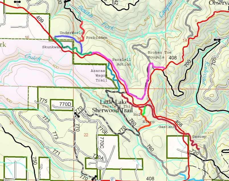
Unofficial Trails near Caspar Orchard Road (Rd. 500)

Cycling Trails in Caspar Area of Jackson State Forest
Please be courteous to equestrians and hikers/dog walkers that frequent this area. Do not ride trails when wet. Trails stay wet weeks after a heavy rain and will be damaged if ridden. Take all your trash out with you. Jackson State Forest has been great about allowing bikes on trails. Please do your best to keep this Forest open to cyclists!
Lower loop. Miles, 3. Fitness level, medium. Skill level, medium.
Lower loop trailhead, Rd 500 at Rd 600, don’t block the gate. Look for 500 Trail a hundred feet down Rd 600 on left. This is fun twisting trail thru redwood, fir, and pine forest. There is a few short steep climbs but most of this trail is not hard to ride. Watch out for large tree roots and sandy corners, ride with caution. Trail ends at T.V. Trail about an eighth mile after crossing Rd 500. You may turn left to return to Lower loop trailhead or turn right and add Upper loop and 4.5 miles to your ride. This trail is an old logging road and it is fairly flat and straight with a lot of large puddles months after rain. Most puddles have by-pass trails around them. Really fast speeds can be reached on this trail. Make lots of noise and expect to see someone on the trail around every corner. T.V. Trail east has some rutted areas and a stream crossing fallowed by a short, steep, rutted climb about an eighth mile from S.H. Trail, at west end is Rd 530. This rocked road is closed to motor vehicles because garbage dumping was a major problem. Road ends at Rd 500 turn left for a few hundred feet to first logging road on right and take this road a few hundred feet to 500 Trail turn right on trail to Lower loop trailhead.
Upper Loop. Miles, 2.5. Fitness level, difficult. Skill level, difficult.
Upper loop trailhead, Rd 500 at Rd 520, don’t block the gate. Look for S.H. Trail a few hundred feet up Rd 500 on left. This is an old logging road that is used illegally by four-wheel drive off roaders. Because of this use there are large ruts and holes on the trail, ride with caution. Follow this trail about a quarter mile to T.V. Trail. You may turn left here to Lower loop or keep straight on Upper loop. After about a mile look for rutted trail on left, this is Three Pipe Trail. This is a very steep climb on an old logging trail. Near the top of the climb look for trail on right. This is Gunslinger Trail that was built by cyclists and has many tight corners and abrupt grade changes. After crossing Rd 500 find Thru Stump Trail to right of gate and more technical trail. This trail ends at Rd 500 across from S.H. Trail. Turn left on road to Upper loop trailhead.
Mendocino Coast Cyclists advocates cycling in all aspects. Promoting responsible and safe trail and road use.
To join send $10 individual, $20 household/organization and any amount extra you would like to donate to; Mendocino Coast Cyclists, P.O.Box 742, Fort Bragg, CA. 95437. Membership entitles you to receive admission to member only events, updates on rides and issues concerning riding in our area, and a 10% discount at Catch A Canoe, Fort Bragg Cyclery, and The Outdoor Store.
This Map and text made by Mendocino Coast Cyclists for personal use only and may not be duplicated without permission
Storm damage cleared from Gas Cap Trail
David Desautels cleared storm damage from Gas Cap Trail. Photos 2/6/07


Subscribe to:
Posts (Atom)